Hydrometeorological hazards
For the Hydrometeorological hazards theme, the CopernicusLAC Platform provides a suite of Earth Observation services designed to support disaster risk management through the detection, monitoring, and analysis of water-related extremes. Leveraging high-resolution data from the Copernicus Sentinel satellites, these services offer timely and actionable insights into both ends of the hydrological spectrum: floods and droughts.
Flood Services
Four dedicated services enable users to assess flood dynamics and associated changes with precision and consistency, leveraging both Sentinel-1 Ground Range Detected and Single Look Complex imagery.
SAR-based Flood Extent Mapping
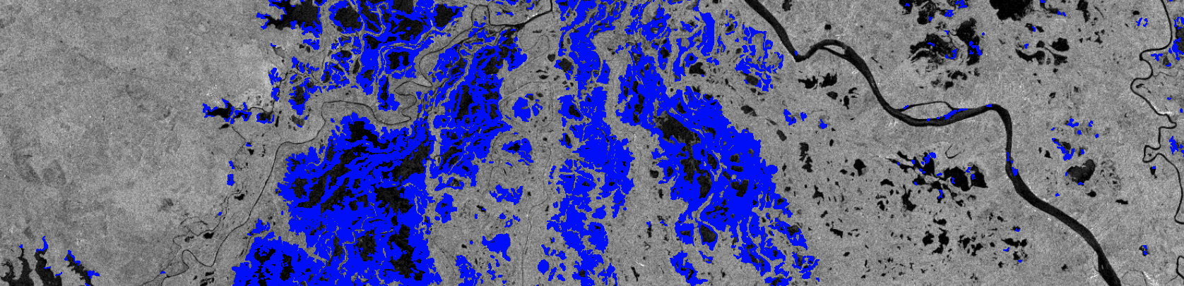
The SAR-based Flood Extent Mapping (SAR-FEM) service provides an estimation of the cumulative extent of flood traces using Sentinel-1 imagery over a defined period around the event start date.
Access the SAR-FEM service information:
SAR-FEM service specifications
Flood Depth Mapping
The Flood Depth Mapping (FLDM) service provides high-resolution maps of maximum water depth per pixel based on flood extent maps and elevation data.
Access the FLDM service information:
SAR-based Flood Frequency Mapping
The SAR-based Flood Frequency Mapping (SAR-FFM) service generates a time series of flood extent maps and an empirical flood frequency map using Sentinel-1 data over a user-defined period.
Access the SAR-FFM service information:
SAR-FFM service specifications
Flood Hazard Mapping
The Flood Hazard Mapping (FHM) service enhances modelled flood hazard maps by integrating them with empirical flood frequency data derived from Sentinel-1 imagery.
Access the FHM service information:
SAR Features
The SAR Features service detects changes in urban areas using Sentinel-1 coherence and intensity data, supporting flood and damage mapping.
Access the SAR Features service information:
SAR Features service specifications
Drought Service
Drought Indices
The Drought Indices (DI) service calculates and combines multiple indices relevant for drought monitoring, including anomalies in precipitation, soil moisture, and vegetation. These indices are derived from Earth Observation data and enhanced through climatic time series analysis to provide a comprehensive view of drought conditions. Access the service information.
Access the DI service information:
Copernicus Context
In addition to the Sentinel missions, the Copernicus programme provides a comprehensive set of services for monitoring and assessing hydrometeorological hazards through the Emergency Management Service (CEMS), the Global Flood Awareness System (GloFAS), the Global Flood Monitoring (GFM) product, and the European and Global Drought Observatories (EDO & GDO).
Copernicus Emergency Management Service (CEMS)
The Copernicus Emergency Management Service (CEMS) supports flood and drought risk management through:
- Rapid Mapping: Near-real-time mapping of flood extent and impact.
- Risk and Recovery Mapping (RRM): Detailed geospatial products for flood hazard characterization, long-term risk mitigation, and post-disaster recovery.
- Early Warning and Monitoring: Integration of hydrological models, meteorological forecasts, and satellite data for proactive risk management.
Details concerning the CEMS are provided in the Annex.
Global Flood Awareness System (GloFAS)
The Global Flood Awareness System (GloFAS) is part of the CEMS Early Warning and Monitoring component. It provides:
- Global-scale flood forecasts up to 30 days in advance.
- Integration of meteorological forecasts, hydrological modeling (LISFLOOD), and satellite/in situ data.
- Tools for visualizing hydrographs, anomaly maps, and flood hazard levels.
Global Flood Monitoring (GFM)
The Global Flood Monitoring (GFM) product offers continuous, automated monitoring of flood-affected areas worldwide, using Sentinel-1 data to detect flood extent with high spatial and temporal resolution.
European and Global Drought Observatories (EDO & GDO)
EDO and GDO provide drought-relevant information such as:
- Maps of drought indicators (e.g. precipitation anomalies, soil moisture, vegetation stress).
- Analytical reports on severe drought events.
- Tools for monitoring drought evolution and severity across Europe and globally.
Access EDO here.
Access GDO here.