SAR-based Flood Extent Mapping service specifications
![]()
Find SAR-FEM service tutorial here.
Service Description
The SAR-based Flood Extent Mapping (SAR-FEM) on-demand service focuses on single-event flood detection, meaning the identification and mapping of flood extent related to a specific flood occurrence, typically defined by a start date and an observation period around it, using Synthetic Aperture Radar (SAR) satellite data. In terms of geophysical products, the SAR-FEM service generates on demand a flood extent map of a single flooding event.
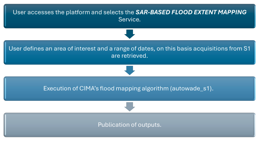
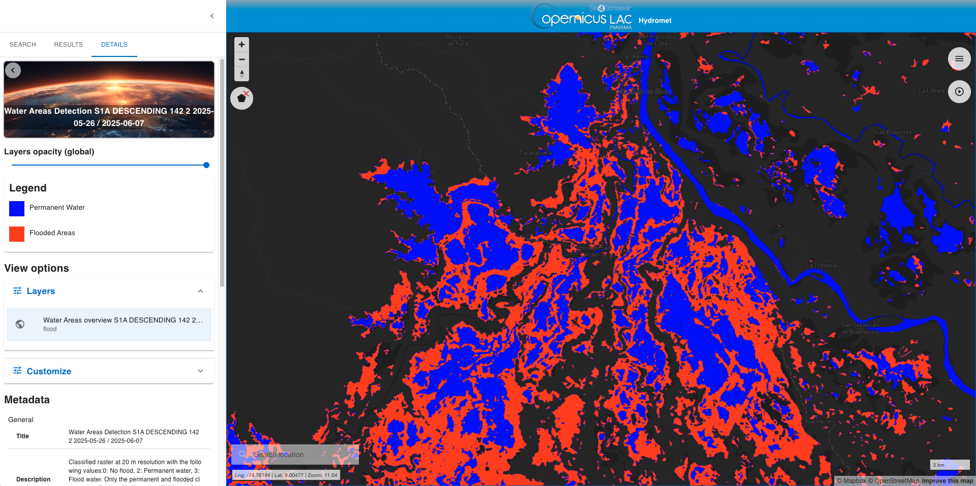
This service exploits a processing chain that uses SAR data (see Figure 3) and focuses on flooded area detection starting from a couple of Sentinel 1 images based on the AUTOmatic Water Areas Detector (AUTOWADE)1,2,[3] algorithm. The user specifies an area of interest and sets the start date of the flood event. The service automatically searches pre- and post-event Sentinel-1 image pairs with the same geometry and relative orbit covering the AOI. The algorithm also uses as input an extract of the ESA Land Cover map and the Copernicus DEM that are used to improve the quality of the flood extent detection. The output is raster in COG format with four classes: no water (0), no-data (1), permanent water (2), and flood (3). On the CopernicusLAC platform, only the flood and permanent water classes will be displayed
Workflow
The schema shown in Figure 3 in this section describes the high-level workflow of the SAR-FEM service.
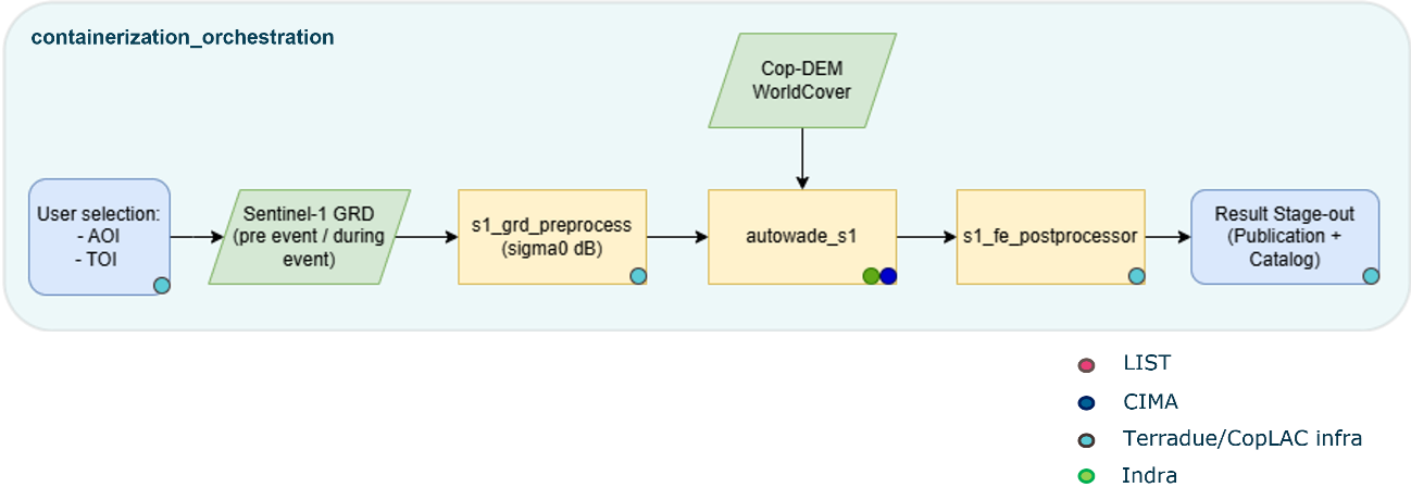
Below are given details of each step of the chain described in the SAR-FEM workflow.
-
User selection: Platform component where users configure parameters for service execution,
-
s1_grd_preprocess: standard preprocessing modules to obtain Sentinel-1 calibrated, corrected and projected sigma nought intensity images in dBs,
-
autowade_s1: CIMA’s algorithms for change detection (Sentinel-1), which execute over all Sentinel tiles fitting into the AOI,
-
s1_fe_postprocessor: modules for image processing to solve noise, border effects and more issues potentially affecting the final result,
-
fe_result_postproc: module for image processing of the final flood extent result,
-
Stage-out: end points of the service to store and visualize the results.
Input
The following inputs are needed to run the SAR-FEM service:
-
A list of Sentinel-1 GRD pairs acquired before and after the event date intersecting the AOI (S1 GRD slices are automatically selected and calibrated by the service),
-
A list of COP-DEM4 tiles intersecting the AOI (these are automatically ingested by the service),
-
A list of ESA World Cover 20215 tiles intersecting the AOI (these are automatically ingested by the service).
Parameters
Table 1 describes the parameters that are needed to run the SAR-FEM service.
| Parameter | Description | Required | Default value |
|---|---|---|---|
| Area of Interest | Area of interest to be covered by the service in WKT (e.g. extent of a district in Colombia) | YES | |
| Event Date (Day) | Date of the event to be used for searching pre- and post-event Sentinel-1 GRD data. | YES |
Output
The SAR-FEM service generated a SAR-Based Flood Extent Map of a single flooding event. Product specifications are:
-
Definition: flood extent as a classified raster having the following values: 0: No flood, 1: Masked pixels, 2: Permanent water, 3: Flood water. Only the "permanent" and "flooded" classes will be displayed in the map with light and dark blue colors respectively.
-
Data type: Geospatial layers
-
Format: raster file in COG format
-
Spatial resolution: 20m.
-
Frequency: obtained on demand
-
Spatial coverage: The service is available for the whole LAC region.
-
Temporal coverage: depending on the revisit time
Service Provider
The service is developed by CIMA Research Foundation.
References
-
Pulvirenti L., Squicciarino G., Cenci L., Ferraris L., Virelli M., Candela L., Puca S. Continuous flood monitoring using on-demand SAR data acquired with different geometries: Methodology and test on COSMO-SkyMed images, ISPRS Journal of Photogrammetry and Remote Sensing, Volume 225 (2025). DOI: 10.1016/j.isprsjprs.2025.04.036. ↩
-
Pulvirenti, L., Squicciarino, G., Fiori, E., Ferraris, L., & Puca, S. (2021). “A Tool for Pre-Operational Daily Mapping of Floods and Permanent Water Using Sentinel-1 Data”. Remote Sensing, 13(7), 1342. DOI: 10.3390/rs13071342. ↩
-
Pulvirenti, L., Squicciarino, G., & Fiori, E. (2020). A Method to Automatically Detect Changes in Multitemporal Spectral Indices: Application to Natural Disaster Damage Assessment. Remote Sensing, 12(17), 2681. 10.3390/rs12172681. ↩
-
Copernicus DEM – Global Digital Elevation Model - COP-DEM_GLO-30. DOI: 10.5270/ESA-c5d3d65. ↩
-
WorldCover 2021 v200 - Zanaga, D., Van De Kerchove, R., Daems, D., De Keersmaecker, W., Brockmann, C., Kirches, G., Wevers, J., Cartus, O., Santoro, M., Fritz, S., Lesiv, M., Herold, M., Tsendbazar, N.E., Xu, P., Ramoino, F., Arino, O., 2022. ESA WorldCover 10 m 2021 v200. DOI: 10.5281/zenodo.7254221. ↩