LSHM service specifications
![]()
Find LSHM service tutorial here.
Service Description
The Landslide Susceptibility and Hazard Mapping (LSHM) service exploits geospatial data and advanced analytical techniques to predict potential landslide susceptibility zones, thereby aiding in risk management and mitigation strategies. It provides the likelihood of a landslide in an area, based on Earth Observation with Sentinel-1 and Sentinel-2, multi-criteria analysis, local information, and Machine Learning.
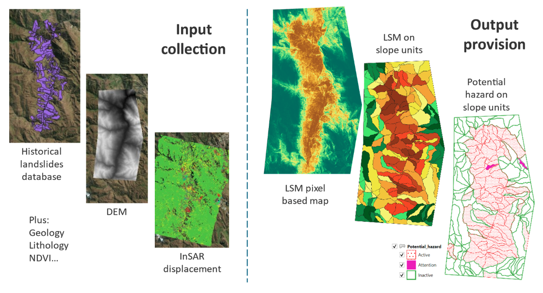
The service exploits information layers provided by the local user (landslide inventory, geology and lithology maps), together with a mix of EO derived products (DEM, NDVI, InSAR displacement maps) to derive the probability of occurring of a landslide and the potential hazard associated to slopes.
Geotechnical slope units (GSUs) are defined automatically in the process; a GSU is a spatial unit used in landslide and slope stability analysis. It represents a portion of terrain with relatively homogeneous geomorphological, geological, and hydrological characteristics. These units are commonly used in landslide susceptibility mapping and hazard assessments.
Typically, the service execution is ranging from a few minutes to a few hours depending on the extent of the user’s AOI, the observation time period, and the allocation of processing resources for the job to be executed. As an example, to employ the LSHM service over an AOI of 75000 ha with all inputs the processing time is of approximately 30 minutes.
Key Characteristics of a Geotechnical Slope Unit (GSU) are:
Defined by Natural Boundaries
-
Typically bounded by ridges, valleys, or drainage divides.
-
Ensures that each unit represents an independent slope system.
-
Homogeneous Geotechnical Properties
-
Similar lithology (rock and soil types)
-
Consistent slope angles and orientations (aspect).
-
Comparable hydrological and mechanical behaviour.
Useful for Slope Stability Analysis:
-
Helps in assessing landslide susceptibility and risk.
-
Improves modelling accuracy by focusing on uniform areas.
Derived from DEM and GIS Techniques:
-
Digital Elevation Models (DEMs) are used to delineate GSUs.
-
Geographic Information System (GIS) tools help process slope-related data.
In terms of products, the LSHM service generates:
-
A pixel based of the landslide susceptibility
-
A slope unit based susceptibility map, determining for each GSU both the average susceptibility and potential hazard through integration with InSAR displacement.
Both the output raster have the same resolution of the input DEM.
In the CopernicusLAC Platform, the data provided from the user plus EO relevant data such as DEM, NDVI and InSAR deformation maps is ingested and automatically processed by means of a Machine Learning (ML) approach (random forest)1. The purpose of this approach is to find the optimal set of conditioning factors that will provide the best fit for the model to yield higher accuracy as predictions. Micheletti et al. (2014)2 emphasized the importance of feature selection in LSHM and discussed the use of ML models such as a support vector machine (SVM), random forest (RF), and AdaBoost (Adaptive Boosting) for LSHM, as well as the significance of associated features within the confluence of the ML models for feature importance. Studies by Liu et al. (2021)3 not only depicted the improvement in the predictive capability of the so-called feature selection machine learning (FS-ML) model but also remarked on the fact that the same conditioning factors may contribute differently in different ML models. The identification of the most crucial features can help in monitoring the effect of extreme events (such as a tornado or an earthquake) on the changes in the evolution of landslide hazard.
Workflow
The schema shown in the below figure describes the high-level workflow of the Landslide Susceptibility and Hazard Mapping service.

The workflow requires an Area of Interest (AOI) plus the provision of the input as described in the section Input.
The proposed procedure for Landslide Susceptibility Mapping is a comprehensive and systematic approach encompassing several key steps:
-
Data Collection: Gather all available datasets related to potential landslide contributing factors (LCFs).
-
Data Derivation: Extract additional LCFs from raw data sources.
-
LCF Mapping: Convert LCF data into a suitable raster format, ensuring the resolution matches the problem's scale.
-
Landslide Inventory: Assemble or map existing landslide incidents and slope instabilities within the study area.
-
Data Sampling: Conduct random sampling to create training, testing, and validation datasets.
-
Model Training: Train a random forest model with hyper-parameter optimization.
-
LCF Analysis: Perform a comparative analysis to determine the importance of each LCF.
-
Parameter Subsetting: Narrow down the parameter space based on the importance analysis.
-
Refined Training: Train the random forest model again using the reduced parameter space.
-
Model Application: Apply and test the optimized ensemble model across the entire study area to estimate landslide susceptibility.
The processing also derives automatically Geotechnical Slope Units (GSU) and determines for each GSU an average value for landslide susceptibility.
Furthermore, the integration with InSAR displacement map is carried out correlating activity status (derived from InSAR) and landslide susceptibility, per each GSU. The final goal is to estimate potential hazard, and representing it in 4 different classes:
-
Active: when a GSU shows both recent displacement and relatively high values of susceptibility
-
Inactive: when a GSU shows both no significant displacement and relatively low values of susceptibility
-
Attention: when a GSU shows both recent displacement and relatively low values of susceptibility
-
Dormant: when a GSU shows both no significant displacement and relatively high values of susceptibility
Input
The LSHM service automatically retrieves from CDSE:
-
COP-DEM tiles which are mosaicked over a user-defined AOI by the service.
-
Sentinel-2 L2A tiles which are mosaicked over a user-defined AOI, and calibrated by the service. The service also automatically derives NDVI from this data.
The user must provide also in input:
-
Geology map, providing geological classes as discrete single band raster in UInt8/Int16.
-
Landslide inventory archive as point vector in GeoJSON format. This file shall provide for each historical event the coordinates of a point that identifies the single landslide.
Warning
The input landslide inventory and geological map are mandatory. The LSHM service will not execute without these two layers. Table 1 provides specifications for these layers to guide users wishing to provide their own data to run the LSHM service.
Optionally (to improve the model) the user can provide:
-
Road network as single band raster. The local user shall provide a road network (1=road,0=background) as binary raster (1=road,0=background). This raster is then transformed into a "distance-to-roads" raster and having 5 classes and then uploaded to the platform. Pixels having value=1 are the ones located within 50m from road centerline, value=2 within 100m, value=3 within 150m, value=4 within 200m, value=5 more than 200m.
-
River network as single band raster. The local user shall provide a river network (1=river,0=background) as binary raster (1=river,0=background). This raster is then transformed into a "distance-to-rivers" raster and having 5 classes and then uploaded to the platform. Pixels having value=1 are the ones located within 50m from river centerline, value=2 within 100m, value=3 within 150m, value=4 within 200m, value=5 more than 200m.
-
Lithology map providing lithology classes as discrete raster in UInt8/Int16.
-
InSAR displacement data for hazard map obtention as tabular file in CSV format. Mandatory attributes are:
CODE(identifier),LAT(in degrees),LON(in degrees),VEL(in mm/year). The service converts automatically velocity from cm/yr or m/yr if needed. It also automatically re-projects InSAR displacements to match the input CRS.
All input datasets are aligned and projected to the CRS of the input DEM, and clipped to an AOI defined by the user
| LSHM Input Data Specifications | |
|---|---|
| Area of Interest | |
| Minimum size | 5 km x 5 km |
| Landslide Inventory Vector | |
| Format | GeoJSON |
| Geometry | Point |
| Projection | EPSG:4326 |
| Position | Centroid of the landslide polygon if polygons are provided. For larger landslides within large AOI regularly spaced points within the landslide affected area can be used. |
| Attribute Value | No set requirement |
| Landslide Inventory Raster | |
| Format | COG |
| Projection | EPSG:4326 |
| Resolution | ~ 30 m (0,0003 deg) |
| Pixel Value | 1 for landslide points; no value for non-landslide points. Convention: UInt16 |
| Notes | The landslide inventory raster is used only for data visualisation in the workspace; it can be rendered both with pixel=1 corresponding to the centroid of the landslide polygon or with pixel=1 for the whole polygon affected. |
| Landslide Inventory STAC Item | |
| Convention | Bbox same as the one of the geology. Geometry corresponding to one individual point: using the centroid of the AOI as identified by the geology extent. |
| Geology Vector | |
| Format | GeoJSON |
| Geometry | MultiPolygon |
| Projection | EPSG:4326 |
| Attribute Value | Different integer numbers for each geology class in the area. No unified criterion for geology class numbers has been defined. |
| Geology Raster | |
| Format | COG |
| Projection | EPSG:4326 |
| Resolution | ~ 10 m (0,0001 deg) |
| Attribute Value | UInt16 with values same as those defined in the geology vector. |
| Geology STAC Item | |
| Convention | Geometry type: “Polygon”. Only include coordinates of the bbox. |
Parameters
The LSHM on-demand service requires a specified number of parameters. The LSHM runs on demand without the need for the user to define many parameters. Table 2 describes the parameters that the user can or must set in the GUI.
| Parameter/Input layer | Description | Required | Default |
|---|---|---|---|
| Reference date | Date in the format YYYY-MM-DD to be used for the computation of NDVI from Sentinel-2 data sensed in the previous 5 days. |
YES | |
| Area of interest | Area of interest in WKT format. All input datasets shall contain the inserted AOI. | YES | |
| Geology map | Catalog reference to the input Geology map in raster format covering the AOI | YES | |
| Landslide inventory | Catalog reference to a point vector providing geolocations of recent landslides occurred over the AOI | YES | |
| Road network | Catalog reference to a Road network raster to be used for computing distance from roads | NO | |
| River network | Catalog reference to a River network raster to be used for computing distance from rivers | NO | |
| Lithology | Catalog reference to a Lithology vector map covering the AOI | NO | |
| InSAR displacement data (ascending) | Catalog reference to a CSV file reporting Lat, Lon, and velocity in mm/year derived from InSAR displacement analysis along the ascending orbit | NO | |
| InSAR displacement data (descending) | Catalog reference to a CSV file reporting Lat, Lon, and velocity in mm/year derived from InSAR displacement analysis along the descending orbit | NO | |
| Input CRS | DEM CRS. Defines the CRS for AOI and optional vector inputs and ensures alignment with DEM (EPSG:4326) | YES | EPSG:4326 |
| InSAR stability threshold | The threshold value (in mm/year) to enable InSAR points classification in stable/unstable. Mandatory in case InSAR is provided. | NO | 4 |
| Slope unit threshold ratio | Fraction of AOI area used as the base threshold for GRASS GIS watershed segmentation (smaller = finer segmentation). | YES | 0.02 |
| Slope unit min area ratio | Minimum allowed slope-unit area (fraction of AOI). Filters very small units. | YES | 0.006 |
| Slope unit max area ratio | Maximum allowed slope-unit area (fraction of AOI). Filters excessively large units. | YES | 0.15 |
Output
The LSHM service provides in output the two types of landslide susceptibility map products described in the below sections.
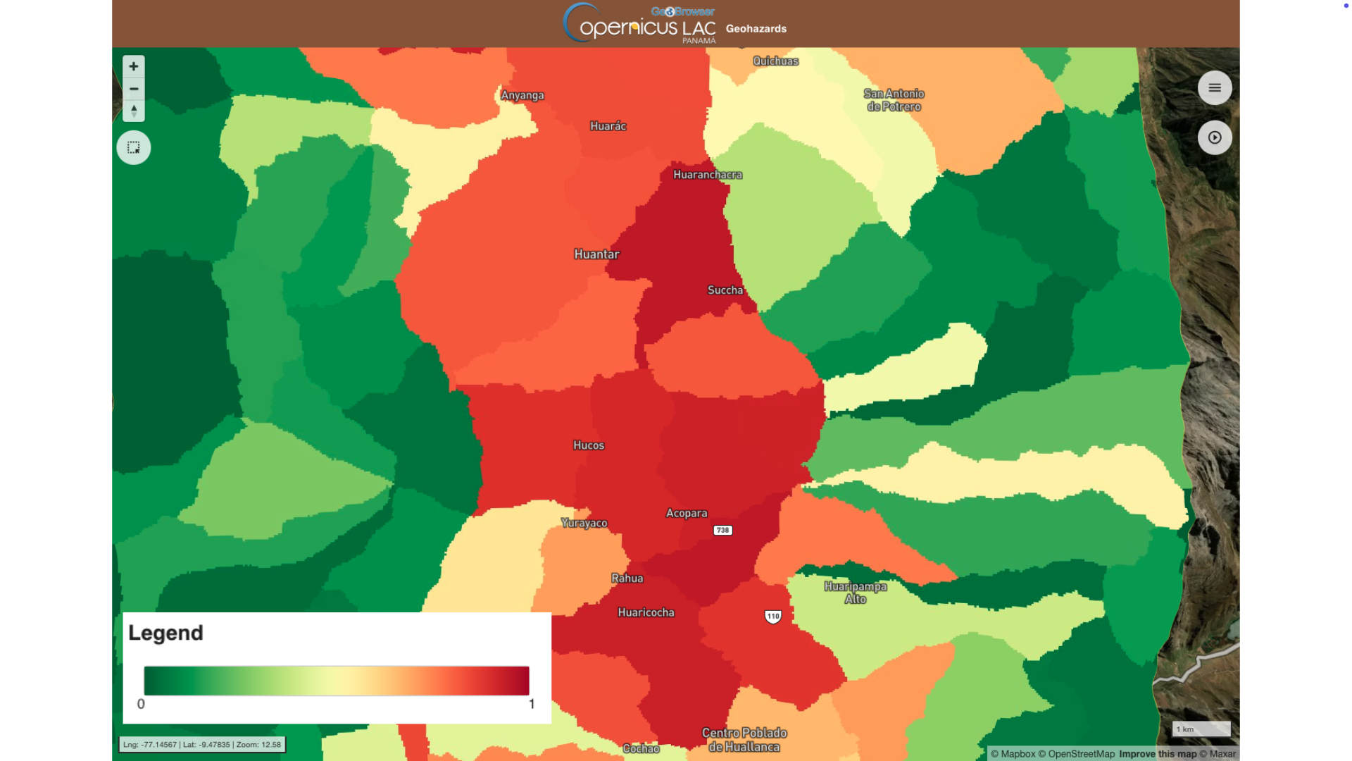
Product A: LSHM pixel based
-
Definition: Raster map, landslide susceptibility defined per each pixel of the input DEM.
-
Data type: Geospatial layers
-
Format: single band raster in COG format
The pixel-based landslide susceptibility is provided in an orthorectified raster in COG format. In the platform each pixel of this product is color coded with respect to the estimated susceptibility using a green (0) to red (1) color map as shown in Figure 3.
![]()
Product B: LSHM slope unit based
-
Definition: Vector map, populated with GSU. Per each GSU an estimation of average landslide susceptibility and (if InSAR is available) potential hazard.
-
Data type: Geospatial layer
-
Format: multipolygon vector file
The slope unit based landslide susceptibility product is provided as a polygon vector in GeoJSON format. In the Geohazards workspace this product is also converted to raster and rendered in the map with a dedicated color-code for:
-
slope units prediction,
-
and potential hazard.
These two rasters derived from the vector product are also given as discrete single band assets in COG format.
Service Provider
The service is developed by Geoapp.
References
-
Meena, S. R., Puliero, S., Bhuyan, K., Floris, M., and Catani, F., (2022) "Assessing the importance of conditioning factor selection in landslide susceptibility for the province of Belluno (region of Veneto, northeastern Italy)", Nat. Hazards Earth Syst. Sci., 22, 1395–1417. DOI: 10.5194/nhess-22-1395-2022. ↩
-
Micheletti, N., Foresti, L., Robert, S., Leuenberger, M., Pedrazzini, A., Jaboyedoff, M., and Kanevski, M. (2014), "Machine Learning Feature Selection Methods for Landslide Susceptibility Mapping", Math. Geosci., 46, 33–57. DOI: 10.1007/s11004-013-9511-0. ↩
-
Liu, L.-L., Yang, C., and Wang, X.-M.: Landslide susceptibility assessment using feature selection-based machine learning models, Geomech. Eng., 25, 1–16, 2021. DOI: 10.1007/s11004-013-9511-0. ↩