World Settlement Footprint 3D layer specifications
Service Description
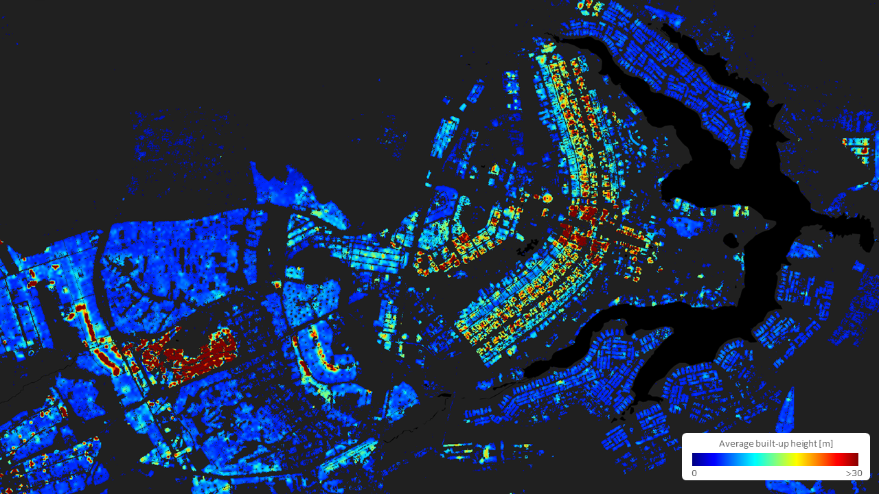
The World Settlement Footprint 3D (WSF 3D) layer is derived from the DLR’s WSF3D to provide global estimates of building height at 10m spatial resolution. The layer combines multiple open-access digital elevation models (DEMs) with AI-derived building height data to generate both raster and vector products representing the vertical dimension of built-up areas. This information supports a wide range of urban applications, including exposure and vulnerability analysis, energy modelling, and sustainable urban planning.
Building height is estimated using an updated version of the WSF3D algorithm, which integrates elevation information from the GLO-30 Copernicus DEM 1, and ALOS World 3D 30m DEM (AW3D30) 2. Two intermediate height layers are generated: one from GLO-30, by measuring elevation differences across neighboring pixels to capture structural edges 3; and one from AW3D30, where ground-level pixels are identified through iterative analysis, followed by the creation of a Digital Terrain Model (DTM) using Natural Neighbor (NN) interpolation 4. For each built-up pixel, the building height is then computed as the difference between the DEM and the DTM. The two resulting height layers are merged using terrain slope as a weighting factor—prioritizing the GLO-30-based estimate in steep terrain and selecting the maximum value elsewhere to ensure stable and accurate results.
The raster product provides average building height estimates for all pixels identified as settlements by the WSF Tracker and is updated periodically, in alignment with the availability of newer or improved elevation data sources (e.g., updated versions of GLO-30, AW3D30, or future global DEMs).
In addition to the raster output, the vector version of the product delivers more detailed, building-level height estimates. This layer is derived by integrating the Google Open Buildings 2.5D dataset 5, which provides AI-predicted building heights from S2 optical data. Average height per individual building is computed using the building footprint geometry from Google Open Buildings 6, and supplemented with OpenStreetMap (OSM) footprints 7 to include more recent constructions not captured by Google. This format enables users to query and analyze height statistics at the level of individual structures or grouped urban zones.
The WSF 3D layer is especially valuable for:
-
Urban Exposure and Risk Modelling: Estimating structural volumes and vertical density for hazard impact assessments.
-
Energy and Emissions Analysis: Supporting building energy consumption modelling and urban heat flux estimation.
-
Planning and Infrastructure: Informing zoning, skyline regulation, and vertical development strategies.
Workflow
The WSF 3D relies on a multi-step workflow to estimate building height for settlement areas, producing both raster and vector outputs:
-
DEM Collection:
- Elevation data are sourced from two global DEMs: the GLO-30 Copernicus DEM and the AW3D30 DEM. These provide complementary inputs for capturing terrain and surface elevation characteristics.
-
Intermediate Height Layer Generation:
-
From GLO-30: Local height variations are computed for each 30m pixel by analyzing elevation differences with neighboring pixels. These values are then assigned to the nearest settlement pixels identified by the WSF Tracker.
-
From AW3D30: Ground-level pixels are identified by iteratively evaluating elevation stability within expanding neighborhoods. A DTM is generated using NN interpolation, and building height is calculated by subtracting the DTM from the original AW3D30 values.
-
-
Fusion of Height Estimates:
-
The two intermediate height layers are merged to produce a consolidated estimate. Terrain slope is used as a weighting factor:
-
In steep areas, the GLO-30-derived height is prioritized for better topographic handling.
-
In flatter regions, the maximum value between the two estimates is retained to ensure robust height assignment.
-
-
-
Raster Output Generation:
- The final height values are assigned to all pixels classified as settlements by the WSF Tracker, producing a raster layer of average building height at 10m resolution.
-
Vector Output Generation:
-
The raster-based height layer is intersected with building footprint geometries from Google Open Buildings and, where needed, OSM to compute average building height per footprint.
-
For each individual building polygon, all overlapping raster height values are extracted and averaged to derive the final height estimate.
-
This results in a vector layer containing building-level height information, suitable for fine-scale spatial queries and statistical summaries. The optional integration of Google Open Buildings 2.5D values may be used to complement or validate height estimates where available.
-
Input
The following inputs are used to generate this layer:
Elevation data:
-
GLO-30 Copernicus DEM: Global digital elevation model at 30m resolution, used to compute height variations based on elevation differences across neighboring pixels.
-
AW3D30 DEM: Global digital surface model at 30m resolution, used to derive terrain elevation through iterative ground point identification and DTM generation.
Settlement extent layer:
- WSF Tracker: Provides the spatial extent of built-up areas, which serves as the mask for extracting building height information from the DEM-based layers.
Building footprints:
-
Google Open Buildings: Provides high-resolution building outlines used for aggregating raster-based heights at the building level in the vector product.
-
OSM: Complements Google Open Buildings by providing additional building footprints in areas not yet covered by Google.
Optional validation/auxiliary data:
- Google Open Buildings 2.5D: AI-derived height estimates from Sentinel-2 imagery, optionally used to support validation or refinement of building-level height values.
Parameters
The following parameters are needed to generate this layer:
- Area of Interest (AOI): the geographical region to be analyzed.
Output
The WSF 3D layer offers two types of products:
Raster product – Average building height per pixel
-
Definition: A raster layer representing the average building height (in meters) for each 10m pixel identified as settlement by the WSF Tracker.
-
Data type: Geospatial raster layer.
-
Format: GeoTIFF.
-
Spatial resolution: 10m.
-
Frequency: Updated periodically, depending on the availability of new or improved DEM sources.
-
Spatial coverage: Global.
-
Temporal coverage: Static; reflects the most recent elevation data available at the time of processing.
-
Constraints: Dependent on the quality and availability of DEM inputs and WSF Tracker settlement extent.
Vector product – Average building height per footprint
-
Definition: A vector layer reporting the average height (in meters) for each individual building footprint, based on the aggregation of raster-based height values.
-
Data type: Geospatial vector layer (polygon-based).
-
Format: GeoPackage or Shapefile.
-
Spatial resolution: Building-level.
-
Frequency: Updated periodically in sync with raster layer updates and footprint dataset releases.
-
Spatial coverage: Global, subject to footprint availability.
-
Temporal coverage: Static; corresponds to the most recent version of input datasets.
-
Constraints: Accuracy depends on the alignment between raster height data and building footprint geometry; limited to areas covered by Google Open Buildings and/or OSM.
Service Provider
The layer is developed by DLR.
Back to Exposure Mapping services
References
-
Copernicus DEM – Global Digital Elevation Model - COP-DEM_GLO-30 https://doi.org/10.5270/ESA-c5d3d65. ↩
-
JAXA. (2019). ALOS World 3D - 30m (AW3D30). Earth Observation Research Center (EORC), Japan Aerospace Exploration Agency. Retrieved from https://www.eorc.jaxa.jp/ALOS/en/aw3d30/. ↩
-
Esch, T.; Brzoska, E.; Dech, S.; Leutner, B.; Palacios-Lopez, D.; Metz-Marconcini, A.; Marconcini, M.; Roth, A.; Zeidler, J. (2022). World Settlement Footprint 3D - A first three-dimensional survey of the global building stock. Remote Sensing of Environment, 270. ↩
-
Marconcini, M.; Marmanis, D.; Esch, T.; Felbier, A. (2014). A novel method for building height estimation using TanDEM-X data. International Geoscience and Remote Sensing Symposium (IGARSS). ↩
-
Google. (2024). Open Buildings 2.5D Dataset. AI-generated building height estimates derived from Sentinel-2 imagery. Retrieved from https://sites.research.google/open-buildings/. ↩
-
Google. (2022). Open Buildings dataset. Version 3. Released under CC BY 4.0. Available at: https://sites.research.google/open-buildings/. ↩
-
OpenStreetMap contributors. (2025). OpenStreetMap: Planet dump. Distributed under the Open Data Commons Open Database License (ODbL). Retrieved from https://www.openstreetmap.org. ↩